A small rock in the Atlantic

All about the island of La Palma, in the Canaries.

Click for La Palma, Canary Islands Forecast

Friday 19 November 2010

Where's the Village Gone?

Map of La Palma municipalities

Tourists sometimes go nuts trying to find the village of Breña Baja, or Fuencaliente.

There's a really simple reason why they can't find them. They don't exist. Breña Baja and Fuencaliente are municipalities, and their town halls are in the villages of San Jose and Los Canarios, respectively. It like driving all over the south east of England, looking for the town of Sussex.

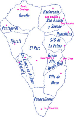
The map shows the 14 municipalities (in blue) , with their administrative seats (in pink). Where
there's no name in pink, the municipalities are named after their chief villages, which makes things simpler. Just to keep things interesting, one, San Andrés y Sauces, is named after the two biggest villages. The town hall is in Los Sauces, which is much bigger and on the main road.

That's easy to find.

Labels: , , , , , , , , , , , , , , ,

Bookmark with:

Del.icio.us Digg Reddit Facebook Furl It Newsvine StumbleUpon ToolbarStumbleUpon

Sunday 14 November 2010

Footpaths on La Palma

Long distance footpath in GarafiaA steep section of long distance footpath in Garafia

La Palma has a network of well-marked footpaths, most of which are centuries old. As late as the 1960s, walking was still a major form of transport for the islanders,

The whole network of hiking trails on the island comes to over 1,000 km, and between them they pass through just about every kind of scenery on the island: lava fields, pine forests, lush laurel forests, farmland and village centres. Some are very short, but this small islands has two long distance paths. The GR 131 runs in a giant question mark from Puerto Tazacorte, up around the Caldera rim, past the Roque, and down the central ridge of the island to the southern tip. Super-fit athletes can run it in a day as an ultramrathon, but normal walkers take at least three days. The GR130 runs right around the island, between sea-level and 1,000 m, which includes a wonderful variety of landscapes. Someone well used to hiking takes about a week. I'm doing it in much smaller installments, but I'm loving it.
Where the two main footpaths meet in FuencalienteWhere the two main footpaths meet in Fuencaliente

Labels: ,

Bookmark with:

Del.icio.us Digg Reddit Facebook Furl It Newsvine StumbleUpon ToolbarStumbleUpon